Author: Dr. Bart Adams, CTO xyzt.ai
Most of what the world buys still crosses the ocean. Much of it then passes through a handful of narrow gates. When one of those gates tightens, the shock does not stay at sea: it moves quickly into oil prices, insurance markets, factory floors and store shelves. This is a risk-ranked tour of the corridors that matter most, and of the geography that keeps maritime planners awake at night.
Pull up a live map of the world’s merchant shipping and the first surprise is how little of the ocean appears to be in use. Trade does not drift across open water in a diffuse haze. It gathers into bright, insistent lines, traced and retraced by tens of thousands of ships. Then those lines narrow, again and again, toward the same small set of passages.
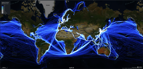
Global commercial shipping — vessel-density heatmap. Source: xyzt.ai
That concentration is the story. The global shipping system does not fail evenly. It fails at the seams, where geography, cargo and politics meet. A closed strait, a withdrawn insurance market, a canal short of rain, a burst of satellite-navigation interference: each can travel outward into energy prices, delivery schedules and the cost of moving almost anything. The vessel-density maps that accompany this piece, produced by xyzt.ai, make the point plain. The maritime economy has a physical shape, and a startling share of it squeezes through gaps a small boat could cross in an afternoon.
The most exposed corridors fall into three broad families. The Strait of Hormuz is the great energy valve, the channel through which Gulf crude, condensate, liquefied natural gas and refined products reach the open ocean. Bab el-Mandeb and the Suez Canal form the live wire of Asia-Europe trade, the route most often forced into costly detours. And the Taiwan Strait is the manufacturing valve, where even a contained crisis could reach into semiconductors, electronics, automobiles and high-value components that industry cannot quickly source elsewhere.
The new anxiety is not simply that one gate might close. It is that several may strain at once: Hormuz under pressure, Bab el-Mandeb under attack, Suez being avoided, Panama short of water, the Baltic clouded by satellite-navigation interference and the Taiwan Strait edging toward escalation. Each would compete for the same finite supply of ships, crews, ports, terminals, fuel, insurance and executive attention. Recent maritime-resilience research increasingly treats this as a network problem, not a single-route problem. Inventories, alternate routes and infrastructure options have to be in place before the shock arrives, not improvised after the queue has already formed.
The risk ranking at a glance
The ranking below is an editorial risk score. It blends current geopolitical exposure, traffic concentration, cargo substitutability, insurance and security conditions, and the likely reach of a disruption. It should be read as a measure of relative pressure across the thirteen corridors that matter most, not as a forecast that any one corridor will close.
|
Rank |
Corridor |
Risk score |
|
1 |
Strait of Hormuz |
10.0 / 10 |
|
2 |
Bab el-Mandeb / Southern Red Sea |
9.5 / 10 |
|
3 |
Taiwan Strait |
8.8 / 10 |
|
4 |
Turkish Straits / Bosporus–Dardanelles |
8.0 / 10 |
|
5 |
Suez Canal / Northern Red Sea |
7.8 / 10 |
|
6 |
Strait of Malacca & Singapore Strait |
7.2 / 10 |
|
7 |
Panama Canal |
6.5 / 10 |
|
8 |
Danish Straits / Baltic entrance |
6.2 / 10 |
|
9 |
Strait of Gibraltar |
5.4 / 10 |
|
10 |
Lombok–Makassar route |
5.0 / 10 |
|
11 |
Sunda Strait |
4.8 / 10 |
|
12 |
Mozambique Channel |
4.6 / 10 |
|
13 |
Cape of Good Hope route |
4.2 / 10 |
Scores are relative and illustrative, not absolute measures of probability.
The corridors, from most exposed to least
1. Strait of Hormuz
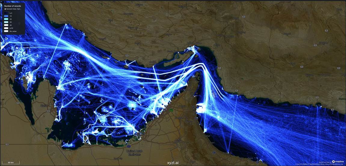
Strait of Hormuz — vessel-density heatmap. Source: xyzt.ai
Between Iran and Oman, at the narrow mouth of the Persian Gulf, lies the most consequential energy chokepoint on the planet. The Strait of Hormuz tops this ranking because the world has built so much of its energy system around a channel with almost no margin for error. Gulf crude, condensate, liquefied natural gas and refined products all converge here, and the geography offers no easy detour.
The risk has sharpened in recent weeks. Renewed military pressure around Iran, reports of reduced commercial transits, ships going dark by switching off AIS signals, and fragile negotiations over access to the strait have turned Hormuz from a standing vulnerability into an active test of the maritime system. Even without a formal closure, harassment, mines, drone activity, insurance withdrawals or a short-lived convoy regime can delay tanker liftings and send tremors through oil, LNG, petrochemicals, fertilizers and freight. A few bypass pipelines exist, but they cannot carry what the strait carries. For operators, Hormuz now demands a voyage-by-voyage risk assessment, confirmed war-risk and kidnap-and-ransom cover, and near-real-time attention to naval and coastal-state advisories.
2. Bab el-Mandeb and the Southern Red Sea
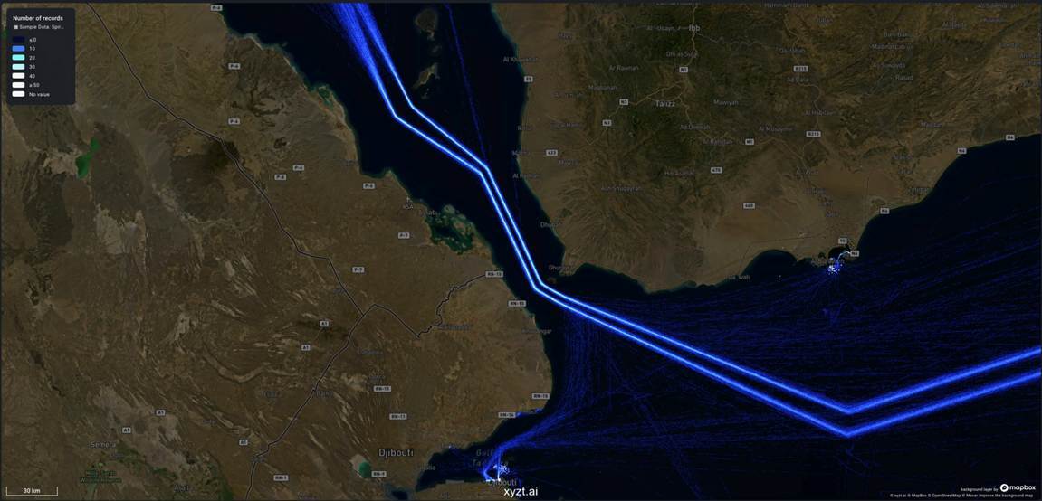
Bab el-Mandeb and the southern Red Sea — vessel-density heatmap. Source: xyzt.ai
If Hormuz is the energy valve, Bab el-Mandeb is the southern doorway to the Suez system. A vessel can clear the canal without incident and still have no dependable route to Europe if the southern Red Sea cannot be insured and crossed safely. Lately, that assumption has been impossible to make for granted.
Missiles, drones and naval escalation have pushed war-risk premiums higher and sent waves of vessels around the Cape of Good Hope, lengthening voyages and absorbing fleet capacity the wider market needs. The U.S. Maritime Administration has continued to warn of Houthi threats to commercial shipping across the Red Sea, Bab el-Mandeb, the Gulf of Aden, the Arabian Sea and the Somali Basin. The practical effect is that 'use Suez' and 'avoid Suez' have become live commercial decisions, revisited week by week, rather than settled assumptions.
3. Taiwan Strait
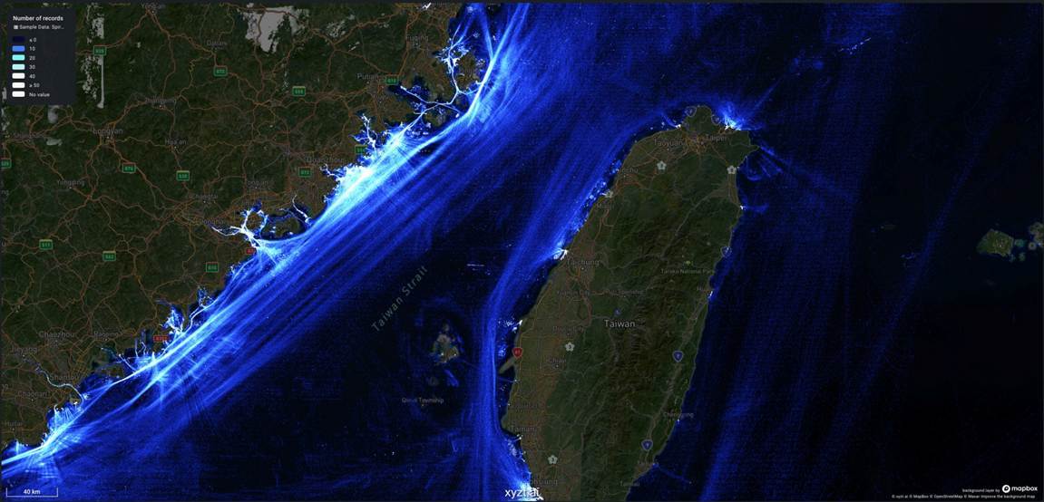
Taiwan Strait — vessel-density heatmap. Source: xyzt.ai
The Taiwan Strait is a different kind of chokepoint. It moves less energy than Hormuz or Malacca. What it carries is the modern economy’s nervous system: semiconductors above all, but also electronics, automobiles and high-value components embedded in production networks with few quick substitutes.
That is why analysts treat even a contained crisis there as a global event. A quarantine, blockade, major military exercise or sanctions regime could force shipping east of Taiwan or through the Philippine Sea while also choking factory output and just-in-time supply chains. Chatham House has warned that a Taiwan crisis could inflict more economic damage than a disruption at Hormuz, a striking judgment given Hormuz’s own weight. For manufacturers, the lesson is not to guess the trigger after the first missile or notice to mariners. It is to set escalation thresholds in advance, diversify suppliers and hold safety stock of the components that cannot easily be replaced.
4. Turkish Straits: the Bosporus and Dardanelles
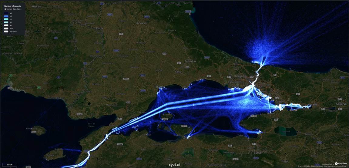
Turkish Straits (Bosporus–Dardanelles) — vessel-density heatmap. Source: xyzt.ai
The Bosporus, the Sea of Marmara and the Dardanelles together form the only way out of the Black Sea by water, and they thread directly through the heart of Istanbul. Down this corridor move grain, oil products, fertilizers, project cargo and a constant flow of regional naval traffic.
War in the Black Sea has layered fresh hazards onto an already demanding transit: mines, drones, sanctions inspections, paperwork delays and war-risk exclusions can turn a routine passage into a commercial bottleneck, and the ordinary traffic-control limits of a crowded waterway add an operational squeeze on top of the geopolitics. Prudent operators now plan strait transits separately from their broader Black Sea exposure, scrutinize ownership and cargo before committing, and keep rail, river and alternative Mediterranean routings in reserve.
5. Suez Canal and the Northern Red Sea
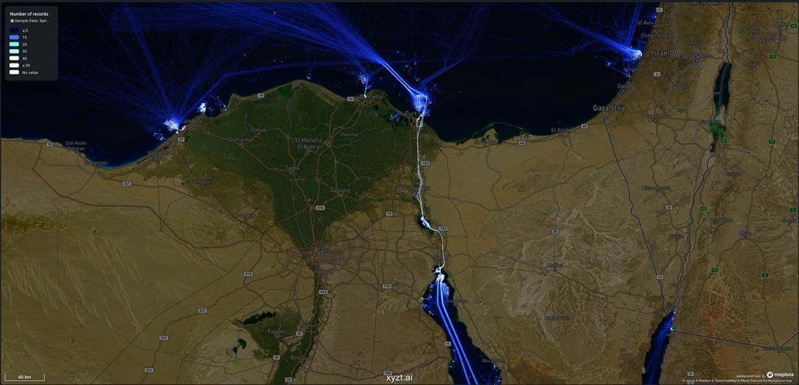
Suez Canal and the northern Red Sea — vessel-density heatmap. Source: xyzt.ai
Suez is shipping’s most famous shortcut, the cut that spares Europe-Asia traffic the long haul around Africa. Its deeper vulnerability is structural: the canal is only as reliable as the seas that feed it. If the Red Sea route is too dangerous or too expensive to insure, Suez loses much of its commercial meaning even while the canal itself remains open.
When that happens, traffic falls back to the Cape and the costs mount quickly: more fuel burned, longer transits, higher emissions, bunched-up port calls and containers stranded in the wrong places. UNCTAD has documented how simultaneous pressure on Suez and Panama exposed the fragility of global supply chains. The operational response is to model Suez-versus-Cape economics continuously, not to treat the canal as a fixed assumption, and to warn customers early that arrival dates can change with the security picture.
6. Strait of Malacca and Singapore Strait
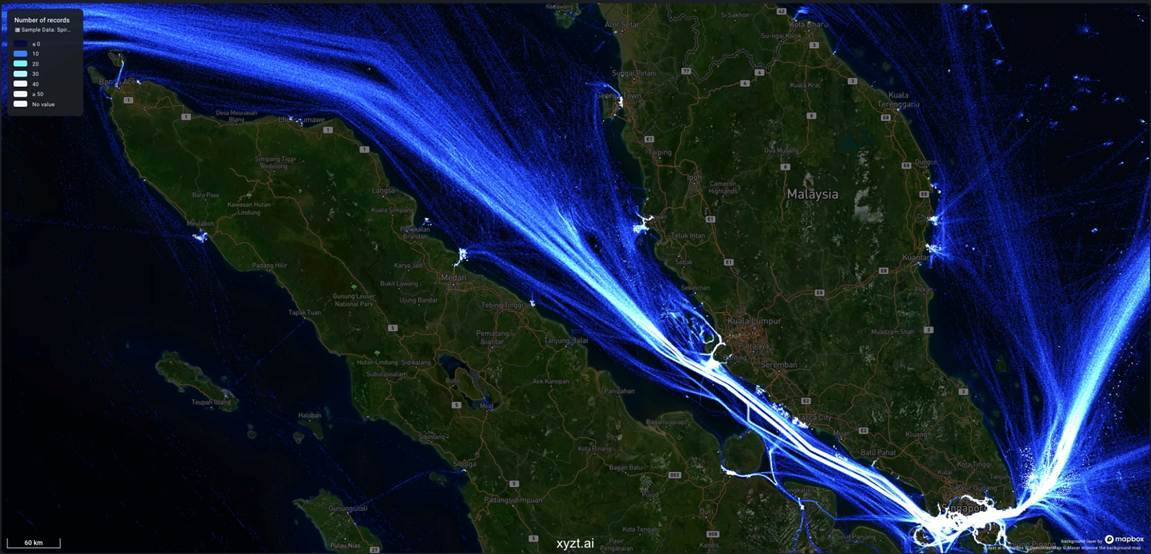
Strait of Malacca and Singapore Strait — vessel-density heatmap. Source: xyzt.ai
Malacca and Singapore form the hinge between the Indian Ocean and East Asia, a corridor carrying a vast volume of container traffic and Asian energy imports. The U.S. Energy Information Administration ranks Malacca alongside Hormuz among the busiest oil chokepoints by volume, a reminder that density itself is a form of risk.
In waters this crowded, congestion, collisions, sea robbery and port delays can ripple through Singapore, Port Klang, Tanjung Pelepas and the dense web of feeder networks that depend on them. ReCAAP, the regional anti-piracy body, recorded 132 piracy and armed-robbery incidents across Asia in 2025, singling out the Straits of Malacca and Singapore as a particular area of concern. Watchkeeping, secured access points and coordination with regional reporting centres are the daily defences; for the largest or most valuable ships, the deeper-water routes through Indonesia offer a costlier fallback.
7. Panama Canal
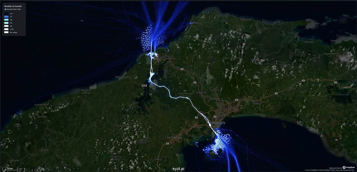
Panama Canal — vessel-density heatmap. Source: xyzt.ai
Panama is the Atlantic–Pacific shortcut that stitches together U.S. East Coast–Asia trade and a long list of cargoes: LNG, LPG, refrigerated goods, grains and containers. Its defining vulnerability is unusual among the world’s chokepoints, because it has less to do with politics than with the weather.
The canal’s locks run on fresh water drawn from inland lakes, and when drought lowers those lakes the consequences are immediate: tighter draft limits, soaring prices for auctioned transit slots and a fog of schedule uncertainty. The Panama Canal Authority’s advisories have become required reading for anyone tracking booking-system changes or lane outages. Shippers respond by booking early, keeping draft flexible and pre-modeling the alternatives — Suez, Cape Horn, or U.S. intermodal rail across the continent — well before a single canal slot turns critical.
8. Danish Straits and the Baltic entrance
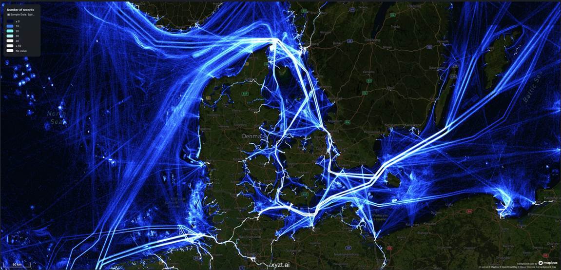
Danish Straits and the Baltic entrance — vessel-density heatmap. Source: xyzt.ai
The Danish Straits connect the Baltic to the North Sea and sit in one of Europe’s most tense maritime neighborhoods: a region thick with sanctions enforcement, shadow-fleet tankers, vulnerable undersea energy infrastructure and naval brinkmanship.
Here the threat is increasingly digital as well as physical. The NATO Shipping Centre has reported interference with satellite navigation affecting merchant ships across the Baltic, Black Sea and Eastern Mediterranean. In congested water, spoofing and jamming raise the odds of collision, grounding or compliance failure all at once. The countermeasure is old-fashioned seamanship reinforced by discipline: bridge teams cross-checking satellite fixes against radar, visual bearings and paper charts, and owners completing sanctions and shadow-fleet due diligence before entering Baltic waters.
9. Strait of Gibraltar
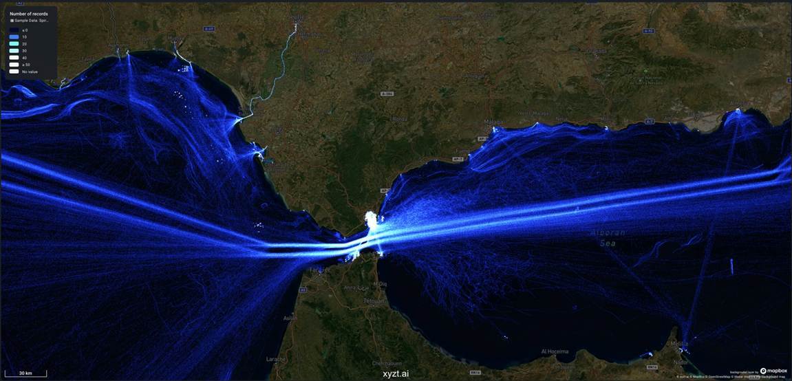
Strait of Gibraltar — vessel-density heatmap. Source: xyzt.ai
Gibraltar, where the Atlantic meets the Mediterranean, is not the world’s hottest geopolitical flashpoint. But it is one of its most crowded and unavoidable passages, a compulsory turn for a great many Europe–Africa and Atlantic–Mediterranean voyages.
Its risks are the quieter, accumulating kind. Heavy traffic and a complex separation scheme, sudden weather, smuggling and migration-security operations, and the occasional regional port disruption can each generate delay and cost without any full-blown crisis. The remedy is unglamorous: strict compliance with the traffic-separation rules, weather buffers, and a roster of alternative bunkering and port options on both shores, from Algeciras and Gibraltar to Tangier Med and Ceuta.
10. The Lombok–Makassar route
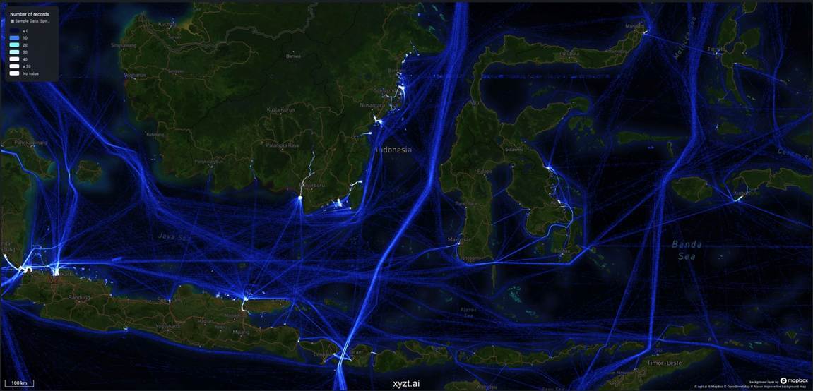
Lombok–Makassar route — vessel-density heatmap. Source: xyzt.ai
Lombok and Makassar rarely make headlines, and that is precisely their value. They are the deep-water back door — the route that large tankers, bulkers and high-value voyages turn to when Malacca or Singapore becomes congested, dangerous or simply unattractive.
The trade-off is distance. Going this way means more miles, more fuel, rougher weather, the constraints of Indonesia’s archipelagic sea lanes and more complicated planning for ports of refuge. In a crisis the route can absorb diverted traffic, but never for free, and operators weigh that fuel-and-time penalty against the congestion or security surcharges they would otherwise face on the busier path north.
11. Sunda Strait
Sunda Strait — vessel-density heatmap. Source: xyzt.ai
Sunda threads between Sumatra and Java, linking the Indian Ocean to the Java Sea. It is a useful regional passage and a partial fallback, but it is no all-purpose replacement for Malacca, and it would be a mistake to treat it as one.
Shallow, narrow water, the volcanic and geological hazards around Krakatau, and firm limits on vessel size all blunt its usefulness for the biggest ships. If Malacca were to seize up, Sunda might catch some of the overflow — but it could not absorb the whole problem on its own. It is best reserved for suitable vessel classes, with Lombok and Makassar held in hand as the genuine deep-draft alternative.
12. Mozambique Channel
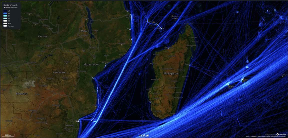
Mozambique Channel — vessel-density heatmap. Source: xyzt.ai
The Mozambique Channel is neither a tight canal nor a strait, and in ordinary times it barely registers as a chokepoint. It becomes one the moment ships start avoiding the Red Sea, because the diversions then pour down the western Indian Ocean and around the foot of Africa, funnelling traffic past the East African coast.
Those Cape-bound voyages carry their own exposures: cyclone seasons, strained East African ports and security concerns off parts of northern Mozambique. Changes to the war-risk and piracy-related listed areas that underwriters watch can shift the route’s economics as well. Operators track the cyclone outlook and the security advisories around Cabo Delgado, and plan bunker stops at Durban, Richards Bay, Maputo or Port Louis as diverted traffic builds.
13. The Cape of Good Hope route
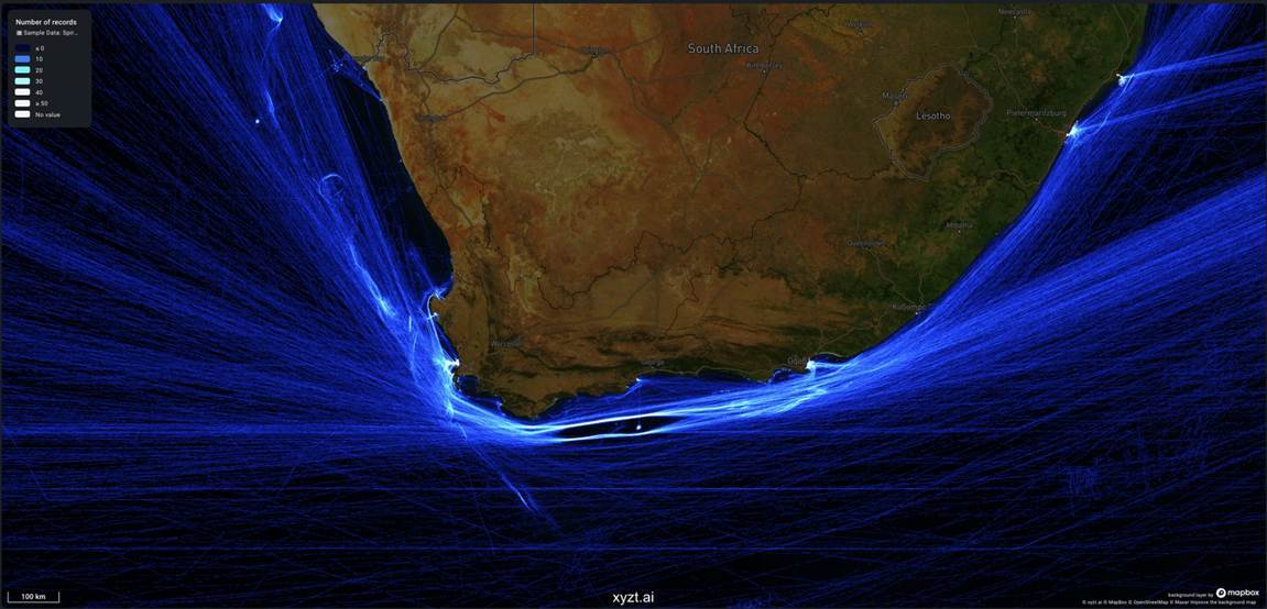
Cape of Good Hope route — vessel-density heatmap. Source: xyzt.ai
The Cape of Good Hope is the odd one out on this list because it is not a chokepoint in the classic narrow-waterway sense. It is the global shipping system’s pressure-relief valve. When Suez and Bab el-Mandeb stop being reliable, the Cape stops being a fallback and becomes the main road, as it has repeatedly in recent years.
There is no security gate to clear here, only the unforgiving arithmetic of distance. Every additional sea mile adds fuel, emissions, charter costs, crewing strain and wear on the ship. Port calls arrive in different waves, empty containers end up in the wrong places, and customer expectations have to be reset from scratch. The Cape’s role is a reminder that the alternative to a chokepoint is rarely cheap; it is simply available.
Planning before the crisis
None of these corridors can be wished away. The geography is fixed and the alternatives are limited. What can change is how prepared an organization is when one of them tightens. The operators that weather these events best tend to have done the thinking before the crisis, when the phone is still quiet and insurance quotes have not yet jumped.
In practice, that means keeping a route-specific risk register for the corridors that matter: Hormuz, Bab el-Mandeb, Suez, Taiwan, Malacca and Singapore, Panama, the Turkish Straits and the Baltic entrance. It means agreeing on rerouting thresholds before a crisis, because waiting for executive sign-off while war-risk premiums climb is too slow. It means tying each route decision to insurance, charter parties, sanctions, arrival dates, fuel and crew in one playbook rather than scattering the problem across departments. It also means keeping backup navigation drills current for the satellite jamming and spoofing now common in the Baltic, Black Sea, Eastern Mediterranean and Arabian Gulf. Above all, it means planning for several chokepoints failing together rather than one at a time.
The maps tell that story in a glance. The world economy does not move across the ocean evenly. It moves through a handful of narrow blue corridors. The moment any one of those corridors becomes political, every supply chain that depends on it becomes geopolitical too. That is why superior maritime intelligence is no longer a luxury reserved for navies and oil majors. It is an operating requirement. Platforms such as xyzt.ai, combining vessel-density intelligence, spatial analytics and live geospatial context, help planners see the pressure points before they become surprises, and make better decisions while there is still time to act.
Sources and further reading
This commentary draws on public maritime-security, energy, shipping and supply-chain sources. Recent reporting on the Strait of Hormuz was used to reflect the latest pressure on commercial shipping. The xyzt.ai maps are used as illustrative vessel-density heatmaps and are not legal route, safety or exclusion-zone guidance.
U.S. Energy Information Administration — World Oil Transit Chokepoints. https://www.eia.gov/international/analysis/special-topics/World_Oil_Transit_Chokepoints
UNCTAD — Vulnerability of supply chains exposed as global maritime chokepoints come under pressure. https://unctad.org/news/vulnerability-supply-chains-exposed-global-maritime-chokepoints-come-under-pressure
U.S. Maritime Administration — Maritime Security Communications with Industry advisory 2026-006. https://www.maritime.dot.gov/msci/2026-006-red-sea-bab-el-mandeb-strait-gulf-aden-arabian-sea-and-somali-basin-houthi-attacks
ReCAAP ISC — Annual Report 2025. https://www.recaap.org/resources/ck/files/reports/annual/ReCAAP%20ISC%20Annual%20Report%202025.pdf
NATO Shipping Centre — Reports on GNSS Disturbances. https://shipping.nato.int/nsc/media-centre/news-archive/2026/nato-shipping-centre-reports-on-gnss-disturbances
Panama Canal Authority — Advisory to Shipping. https://pancanal.com/en/maritime-services/advisory-to-shipping/
Chatham House — A Taiwan crisis would cause far more global economic damage than Strait of Hormuz disruption. https://www.chathamhouse.org/2026/04/taiwan-crisis-would-cause-far-more-global-economic-damage-strait-hormuz-disruption
JWLA.ai — Joint War Committee Listed Areas Interactive War Risk Map. https://jwla.ai/
Sharma and Lau — Securing the Flow: Maritime Energy Resilience under Correlated and Decision-Dependent Disruptions. https://arxiv.org/abs/2605.11990
Associated Press — U.S. says it struck a commercial ship trying to breach blockade and reach Iran. https://apnews.com/article/aeea91e1d1682e7e22321512e6e4aa35
The Wall Street Journal — Ships Are Sailing 'Dark' to Sneak Out of Strait of Hormuz. https://www.wsj.com/world/middle-east/ships-are-sailing-dark-to-sneak-out-of-strait-of-hormuz-0db91dcf
Financial Times — Two LNG tankers pass through Strait of Hormuz. https://www.ft.com/content/9d2cdd87-5f4c-4ce1-a2d1-610729dd4aa9