xyzt.ai, a Leuven-based high-tech company offering an innovative no-code geospatial platform for visualizing and analyzing vast amounts of movement and time series data, is excited to announce the release of its latest feature update, offering enhanced capabilities to analyze and visualize movement data.
The new release introduces multi-scale trajectories, world-oriented icons, and advanced analytics, empowering users to implement accurate real-time digital twins for moving assets as well as to perform detailed and accurate replays for situational awareness and incident analysis.

Multi-Scale Trajectories for Movement Data
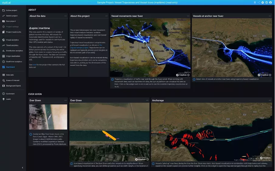
xyzt.ai’s platform now offers trajectories as a data representation option, enabling users to visualize movement data as lines. This novel multi-scale tiled data structure ensures the retrieval of relevant data at an appropriate level for the viewer or analyst, avoiding information overload while maintaining smooth and interactive response times. With data-driven styling, filtering, time-based filtering, and animated replays, trajectories provide improved visualizations for analyzing movement patterns, such as ships in a port or trucks navigating city centers.
World-Oriented and World-Sized Icons
Building on the trajectory feature, xyzt.ai introduces world-oriented and world-sized icons for movement data. Users can now visualize icons with the correct data-driven orientation and dimensions based on their datasets. By incorporating information such as heading, width, length, and GPS device position, the platform accurately places icons and adapts their sizing to remain visible even when zoomed out. This feature brings precise situational awareness to intelligence analysts and offers valuable insights into the movement of various entities, including vessels, aircraft, cars, and trucks.
Advanced Analytics: Convoy Detection, Including Ship-to-Ship Transfers
xyzt.ai continues to expand its platform with advanced space-time analytics capabilities. The latest addition is convoy detection, which enables the identification of groups of entities moving together. This powerful feature has numerous applications, including ship-to-ship transfer detection in the maritime intelligence domain. Convoy detection is available as an add-on and can be obtained by contacting xyzt.ai for more information.
“The latest feature release from xyzt.ai represents a significant advancement in the analysis and visualization of movement data,” said Bart Adams, CTO at xyzt.ai. “Handling big data sets with hundreds of millions to billions of location points and allowing analysts to view and analyze them as lines or trajectories is not an easy task. However, the information obtained by literally connecting the dots can be extremely valuable and provide additional insights in the movement flows unlocking the full potential of connected vehicle data. We are committed to providing innovative solutions that empower organizations across industries to make data-driven decisions with ease.”
To learn more about the new features and their benefits, visit the xyzt.ai website or consult the product documentation.
Interested to know more? Get in touch with us today.
For press inquiries, please contact:
xyzt.ai
About xyzt.ai
xyzt.ai is a high-tech location intelligence company that brings its users actionable business insights through a no-code geospatial platform for visualizing and analyzing big movement data from any moving assets, such as vehicles or vessels, or time series data from non-moving sensors, such as cameras, air quality and noise pollution sensors.
It does so in a unique and effortless way: Customer setup takes less than a day, there is no custom development needed, and insights can be obtained in an interactive way, even for billions of location records.
xyzt.ai is supported by Plug and Play Tech Center, one of the largest accelerators in the world with headquarters in Silicon Valley, by Flanders Innovation & Entrepreneurship and Flanders Investment and Trade.
xyzt.ai is a member of the Open Geospatial Consortium, is named an IDC Innovator for offering groundbreaking location and geospatial intelligence solutions, is part of the Global Top 100 Geospatial Companies selected by Geoawesomeness and winner of the Maritime Innovation Challenge by INEOS and Port of Antwerp.
More information is available at www.xyzt.ai

