Leuven, 24 October 2022 – xyzt.ai, a Leuven-based high-tech company offering an innovative no-code geospatial platform for visualizing and analyzing vast amounts of movement and time series data, announces today that its platform has seen a major re-design and upgrade to better handle multiple data sets at once during analysis.
Analysts in the mobility, traffic, maritime, and intelligence domains increasingly rely on multi-source information for their insight generation.
Being able to handle multiple data sources at once, in a common spatial and temporal reference provides tremendous benefits compared to closed-box solutions that are designed for one, and one type of data set only.
Users of the xyzt.ai platform can now attach any number of data sources to a project and easily analyze them in a common 4D reference.
The user interface has been re-designed and streamlined for better handling multiple data sets at once, allowing users to interact with dozens of layers of data on the maps, timelines, and widgets.
Multi-source mobility analysis
Being able to handle multiple data sources and correlate information in a visual and informative way is important for today’s mobility analyst who must deal with many different data sources.
This includes road intelligence data, such as time series over road segments with traffic density and average velocities, or floating vehicle data sets with waypoints combined in trips, road incident data such as near-crashes, or telecom data containing origin-destination information about how people move across a country.
With the xyzt.ai platform, these data sources can now all be combined in an interactive easy-to-use multi-layered interface.
Multi-source maritime analysis
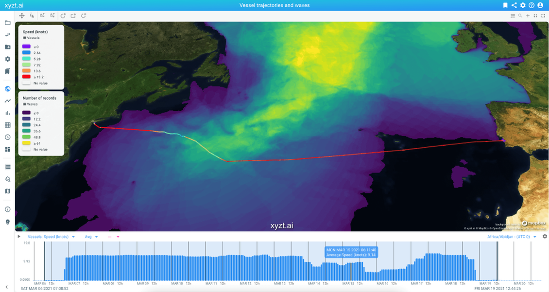
Also in the maritime domain, multi-source intelligence and situational awareness is important. Think about analyzing a vessel journey and behavior in combination with the ocean environment. Data sets with weather information, ocean information, and vessel IoT data need to be easily combinable in a single common situational picture.
With xyzt.ai, analysts can now look and understand all parameters at once, even for multiple large spatio-temporal data sets covering multiple weeks of information.
“We listened to the feedback of our users and carefully designed and implemented new interaction workflows and interfaces to handle multiple data sets at once. This was not an easy task, as data sets not only differ by the type of information they contain, but also possibly by the spatial and temporal reference that need to be handled properly in a correct common reference frame.”.
Dr. Bart Adams, CTO & Founder at xyzt.ai
Interested to know more? Get in touch with us today.
For press inquiries, please contact:
xyzt.ai
Lida Joly
Founder & CEO
About xyzt.ai
xyzt.ai is a high-tech location intelligence company that brings its users actionable business insights through a no-code geospatial platform for visualizing and analyzing big movement data from any moving assets, such as vehicles or vessels, or time series data from non-moving sensors, such as cameras, air quality and noise pollution sensors.
It does so in a unique and effortless way: Customer setup takes less than a day, there is no custom development needed, and insights can be obtained in an interactive way, even for billions of location records.
xyzt.ai is supported by Plug and Play Tech Center, one of the largest accelerators in the world with headquarters in Silicon Valley, by Flanders Innovation & Entrepreneurship and Flanders Investment and Trade.
xyzt.ai is a member of the Open Geospatial Consortium, is named an IDC Innovator for offering groundbreaking location and geospatial intelligence solutions, is part of the Global Top 100 Geospatial Companies selected by Geoawesomeness and is winner of the Maritime Innovation Challenge by INEOS and Port of Antwerp.
More information is available at www.xyzt.ai

