
Cities are sitting on a hidden asset: traffic data that already exists but is rarely used to its full potential.
One of the most overlooked sources of insight is floating vehicle data (FVD). This type of traffic data provides large-scale, anonymized movement information that shows how vehicles actually move through a city over time. Despite its potential, many cities still rely on limited samples, manual surveys, or outdated tools to understand traffic patterns.
The result is a major blind spot in traffic planning and mobility decision-making.
This article explores what traffic data cities already have, why floating vehicle data often remains underused, and how traffic analytics can help unlock its value.
What Traffic Data Cities Already Have
Many cities already collect large volumes of traffic and mobility data through everyday operations. This includes data generated by vehicles moving through the road network and infrastructure systems designed to monitor traffic flow.
Among these sources, floating vehicle data stands out because it captures continuous movement across the entire road network rather than isolated locations.
Floating vehicle data typically consists of anonymized GPS traces that describe:
- where vehicles travel
- when they move
- how traffic patterns change over time
This makes it particularly valuable for understanding real-world traffic behavior at scale.
What Is Floating Vehicle Data and Why Cities Overlook It
Floating vehicle data provides a dynamic view of traffic conditions, but it is still underused in many cities.
Common reasons include:
1. Data volume
Floating vehicle data can consist of billions of records. Without scalable traffic analytics tools, this volume becomes difficult to manage and analyze.
2. Fragmented datasets
Traffic data often comes from multiple sources and time periods, making it challenging to analyze consistently.
3. Limited spatio-temporal analysis
Traditional tools are often not designed to analyze traffic data across both space and time simultaneously, which is essential for meaningful insights through spatio-temporal traffic analysis.
As a result, valuable traffic data remains stored rather than actively used in decision-making.
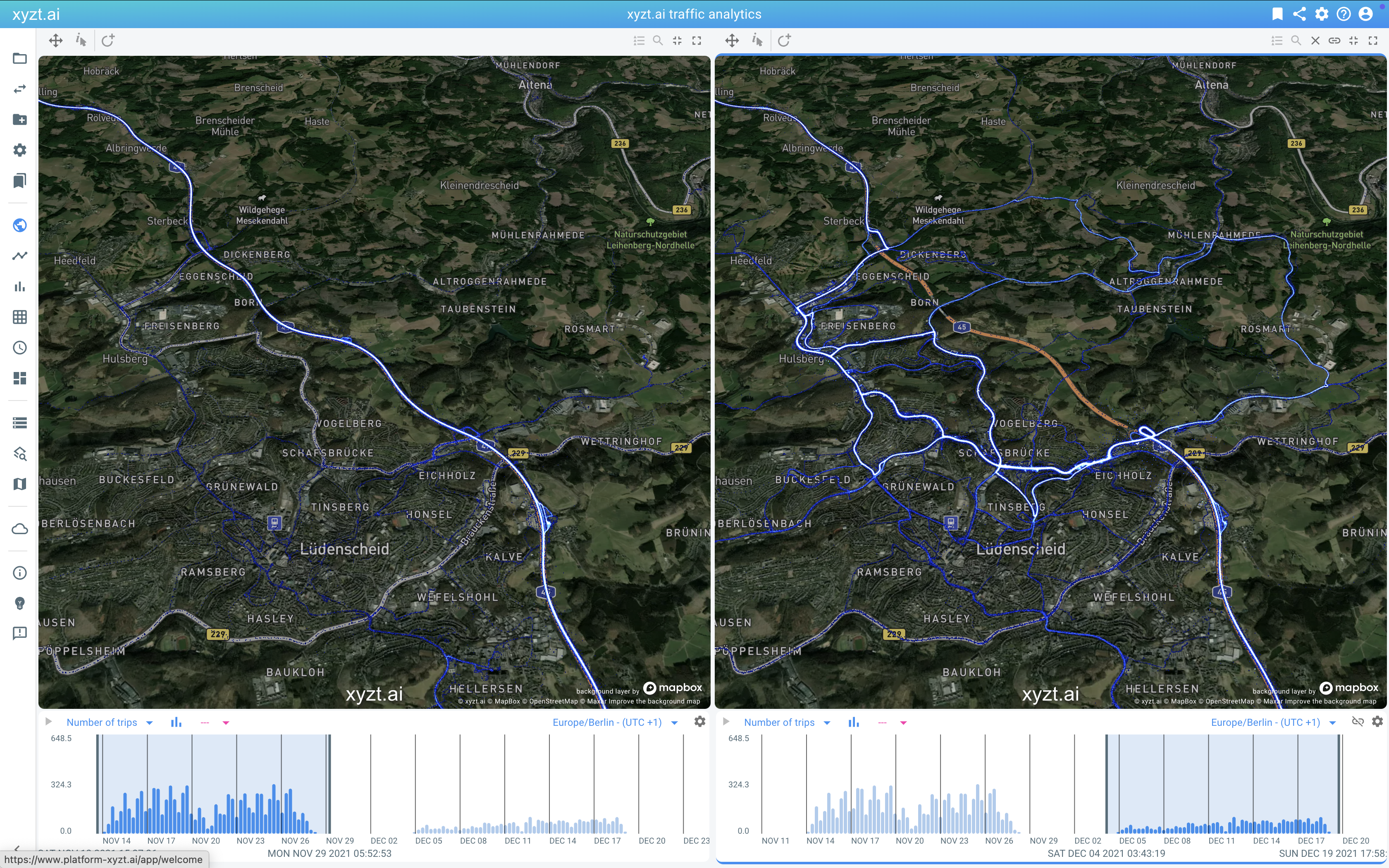
Case Example: Large-Scale Traffic Data in Hamburg
Hamburg is an example of a city with access to extremely large volumes of floating vehicle data. With tens of billions of traffic records available, the city has the potential to analyze:
- peak-hour congestion patterns
- route choice behavior
- the impact of roadworks and infrastructure changes
However, without the right traffic analytics workflows, this data risks becoming an underused archive instead of a decision-support tool.
How Traffic Analytics Unlock the Value of Floating Vehicle Data
To make floating vehicle data actionable, cities need traffic analytics solutions that can:
Process data at scale
Analytics tools must handle large volumes of traffic data without extensive preprocessing.
Support spatio-temporal analysis
Understanding traffic patterns requires analyzing how movement changes across locations and over time.
Enable exploration and visualization
Interactive analysis helps planners identify patterns, anomalies, and trends within traffic data.
Translate insights into decisions
Traffic analytics should support practical outcomes such as traffic management, mobility planning, and infrastructure evaluation.
Reducing the Cost of Traffic Analysis
Traditional traffic studies often rely on manual counts, temporary sensors, or repeated surveys. These approaches are expensive, time-consuming, and difficult to scale.
By contrast, traffic analytics based on floating vehicle data reuse data that already exists. When combined with scalable spatio-temporal analytics, this can reduce the cost of traffic analysis by an order of magnitude, while also increasing coverage and update frequency.
From Traffic Data to Better Mobility Decisions
When floating vehicle data is effectively analyzed, cities can move beyond assumptions and static reports. Instead, they gain evidence-based insights that support:
- data-driven traffic planning
- improved mobility strategies
- better-informed infrastructure investments
This shift allows traffic data to become an active input into everyday urban decision-making.
Q&A: Floating Vehicle Data and Traffic Analytics
What is floating vehicle data?
Floating vehicle data is anonymized movement data collected from vehicles, typically based on GPS traces, that shows how traffic flows across a road network over time.
Why is floating vehicle data valuable for cities?
It provides large-scale, real-world insight into traffic patterns, enabling cities to analyze congestion, route choice, and mobility trends more accurately.
Why do cities struggle to use floating vehicle data?
The main challenges are data volume, fragmented datasets, and a lack of tools designed for spatio-temporal traffic analysis.
Curious what you could uncover? Request a demo and find out.
You might also like: