Three shifts redefining how spatial analytics creates value today.
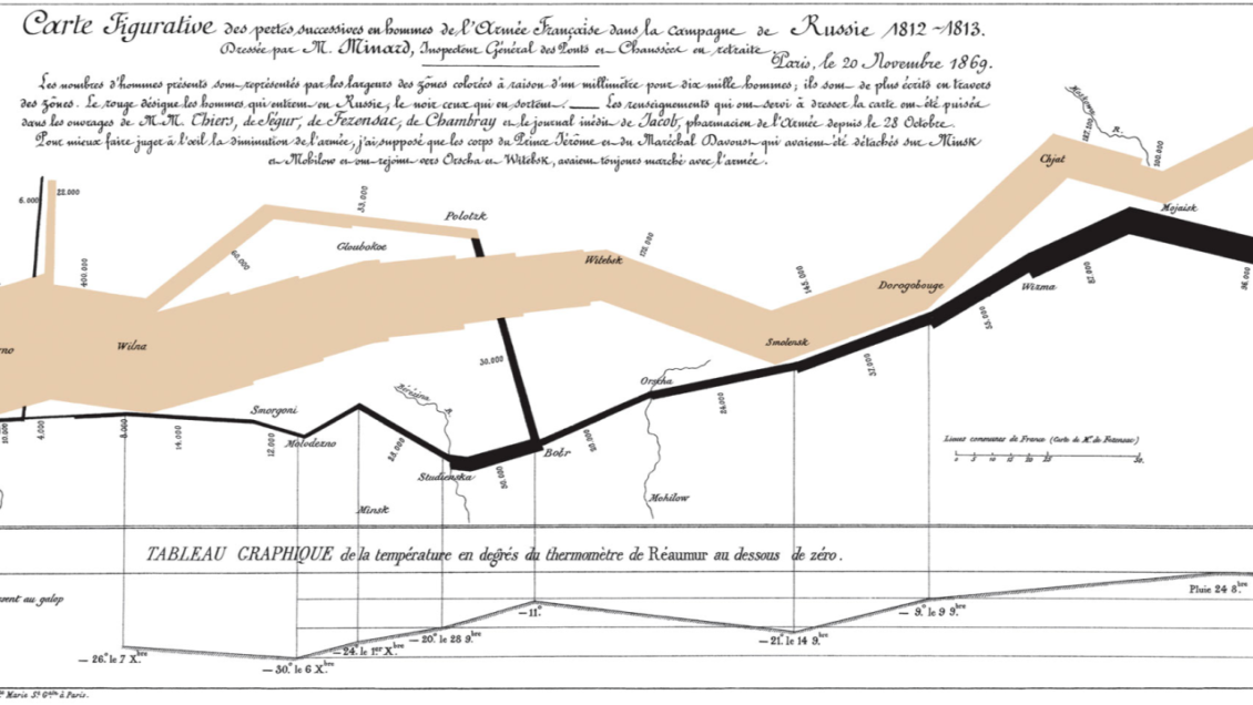
In 1869, Charles Joseph Minard visualized Napoleon’s Russian campaign and revealed something still overlooked today: maps alone don’t explain reality — time does.
In spatial analytics, time is not an extra dimension — it is a prerequisite.
Location without time provides context, but it cannot support decisions. Movement only becomes meaningful when analyzed as sequences, durations, and change over time.
Across mobility, maritime, and safety & security, the organizations creating the most impact treat time as a first-class analytical dimension, not an afterthought.
Today, organizations are collecting unprecedented volumes of location and movement data: Traffic sensors. AIS signals, floating vehicle data, cameras, IoT, and operational systems. The challenge is no longer data availability. The real challenge is answering the questions that actually drive decisions:
- When does congestion start — and when does it disappear?
- When does behaviour deviate from normal patterns?
- When should action be taken for maximum impact?
Spatial analytics has long focused on where things happen. But in real operations, time determines relevance.
Based on our work with customers worldwide, we see three shifts that are redefining how spatial analytics creates value today.
Shift 1: From “where” to movement over time
Traditional spatial analytics answers static questions:
- Where are incidents concentrated?
- Where is density highest?
- Where do assets operate?
But operations don’t happen in snapshots. They unfold over time. Our customers increasingly need to understand:
- When traffic conditions change — and how fast
- When behaviour deviates from the norm
- When interventions work — and when they don’t
This is where spatio-temporal analytics becomes essential.
By analysing movement paths, sequences, durations, and transitions, organizations can:
- Anticipate congestion instead of reacting to it
- Detect abnormal behaviour earlier
- Compare before / during / after scenarios
- Understand not just what happened, but when and for how long
👉 The “when” turns maps into decision timelines.
Technical note: Spatial vs. Spatio-Temporal Analytics
Spatial analytics focuses on relationships in space: geometry, proximity, density, and spatial correlation at a given point in time or over aggregated periods. Outputs are typically static layers, heatmaps, or spatial summaries answering where patterns exist.
Spatio-temporal analytics treats time as a first-class dimension, analysing sequences of spatial states rather than isolated snapshots. It models movement paths, event ordering, durations, transitions, recurrence, and change over time, enabling questions such as when patterns emerge, how long they persist, how fast they evolve, and how behaviour differs before, during, and after events.
In practice, this means moving from spatial joins to trajectory and sequence analysis, from static aggregates to time-resolved distributions, and from point-in-time KPIs to temporal baselines and deviations.
👉 The analytical unit shifts from location to movement in time — a prerequisite for prediction, anomaly detection, impact assessment, and operational decision-making.
Shift 2: AI only creates value when time is explicit
AI is now widely used in spatial analytics — for prediction, anomaly detection, and pattern recognition. But without a strong temporal foundation, AI insights remain shallow. In real operational environments, organizations need AI that understands:
- Trends vs. incidents
- Recurring patterns vs. one-off events
- Short-term disruptions vs. structural change
This requires AI models built on time-aware movement data, not just spatial overlays. Equally important:
- Outputs must be explainable in time
- Results must align with operational decision windows
- Insights must respect governance, privacy, and regulatory constraints
AI becomes actionable only when it answers: 👉 What will happen, when will it happen, and how confident are we?
Shift 3: Temporal analytics must scale beyond experts
Time-based movement analysis has traditionally been complex and expert-driven. That approach no longer scales. Forward-looking organizations are embedding temporal intelligence into reusable workflows so that:
- Planners compare before vs. after interventions
- Operators monitor live vs. historical patterns
- Decision-makers assess short-term impact vs. long-term trends
This shifts organizations from reactive reporting to proactive decision-making, without increasing analytical bottlenecks. Experts don’t disappear. Their expertise is multiplied.
What this means for mobility, maritime, and safety & security
When space and time are analyzed together, organizations unlock entirely new capabilities:
- Safer and more predictable operations
- Better infrastructure and capacity planning
- Faster detection of emerging risks
- Stronger evidence for policy, investment, and compliance
- New opportunities to monetize data and insights
Spatial analytics is no longer about where things are. It’s about how things move — and when it matters.
Looking ahead
The future of spatial analytics is not about adding more features, but about making time explicit in every analysis.
The organizations gaining the most value are those that treat time as a core analytical dimension, not an afterthought.
👉 If you’re working with movement data and want to understand when insights truly matter, we’re happy to share concrete examples.
🔗 Explore real-world use cases 📩 Or reach out for a short demo tailored to your mobility, maritime, or safety challenges
You might also like: